
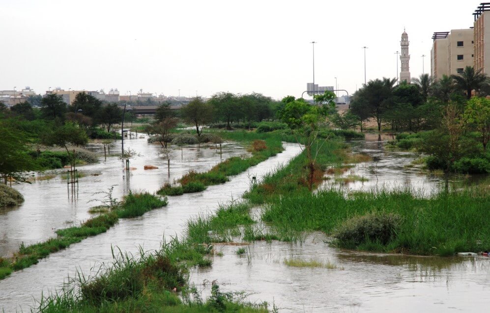
أطلقت الهيئة العليا لتطوير مدينة الرياض خطة لإدارة الفيضانات في وادي حنيفة ووادي السلي وذلك بالتعاون مع لجنة الطوارئ بمدينة الرياض وأمانة منطقة الرياض والمديرية العامة للدفاع المدني. وتهدف هذه الخطة لمراقبة هطول الأمطار وجريان السيول بوادي حنيفة ووادي السلي، والحد من الأضرار التي تنتج عن الفيضان أثناء مواسم الأمطار. وتأتي هذه الخطة استجابة للتغيرات المناخية التي حدثت مؤخراً، والتي أدت إلى تزايد احتمال تعرّض المناطق الواقعة في الواديين وفروعهما لمخاطر الفيضانات. كما تسعى من خلال هذه الخطة إلى حماية الأرواح والممتلكات على ضفاف الوادي، وحماية المنشآت القائمة فيه. وبموجب سلسلة متتالية من الدراسات أجرتها الهيئة عن الواديين، تضمنت إعداد نماذج رياضية للفيضانات، في الوقت الذي جرى فيه الأخذ بعين الاعتبار المعلومات الهيدرولوجية المتوفرة لدى الهيئة والجهات الأخرى حوله، وبعد الاطلاع على التجارب العالمية الناجحة في إدارة الفيضانات وأفضل الممارسات في هذا المجال، تم تركيب محطات مراقبة لتحديد كميات الأمطار وارتفاع منسوب المياه في الواديين وقياس شدة التدفق والسيول، وتشغيل برنامج لتحليل البيانات والاستفادة منها. ويذكر أنه يتم إعداد التقارير الفنية والمؤشرات بشكل دوري.
وتضمنت الخطة تحديد مسارات القنوات وأطوالها وتأثير الامتداد العمراني للأحياء السكنية، ومعرفة السعات التخزينية. بالإضافة إلى جمع المعلومات المناخية المتوفرة للواديين وتحليلها وتحديد السيناريوهات المختلفة لمعدلات سقوط الامطار وشدتها، وذلك لتقدير حجم ومعدلات التدفقات من الأحواض المائية في الواديين وفروعهما للفترات الزمنية المستقبلية المتوقع حدوثها مع التغيرات المناخية. كما حددت الخطة أكثر المناطق المعرضة للغمر بمياه الفيضانات في الواديين، وأعماق وسرعة جريان المياه فيها.
تغطي خطة إدارة الفيضانات كامل منطقة حوض التجميع الرئيسي لوادي حنيفة، والأودية الفرعية والتي تقدر بنحو 4000 كم2، وتمتد من الحيسية شمالاً حتى بحيرات الحائر جنوباً بطول 120كم، إضافة إلى العديد من الأودية الفرعية والشعاب الرئيسية والصغيرة التي تصب فيه، كما تغطي وادي السلي الممتد طوله حوالي 176 كم.
يتم جمع تلك المعلومات وتحليلها ومن ثم تقديم الإجراء المقترح إلى الجهات ذات العلاقة للتقليل من مخاطر جريان مياه السيول والأمطار، وستعتمد هذه الخطة على مجموعة من البرامج والأنظمة والإجراءات لإدارة الفيضان قبل وأثناء وبعد وقوعه، كما تشمل برنامج للمراقبة، ونظام للإنذار المبكر، وبرامج للتوعية والتوجيه، وإرشادات وضوابط للملاك في الوادي، وتنفيذ مشاريع لمعالجة المواقع المعرضة لمخاطر الفيضانات والتي تقع داخل مجاري السيول المعتمدة.
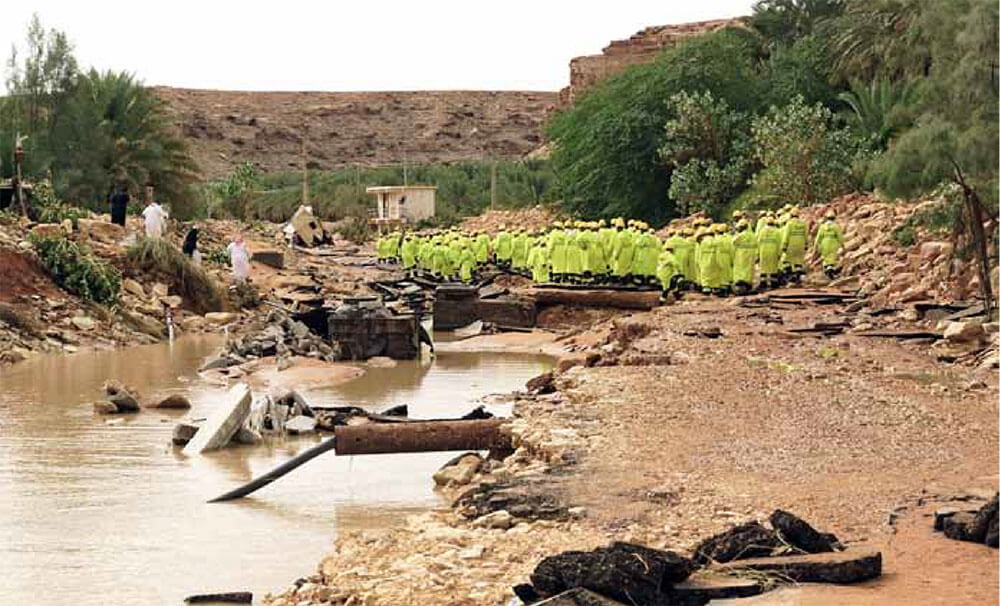
وعلى ضوء هذه الخطة، أقر الاجتماع تشكيل فريق عمل دائم مكون من الهيئة العليا لتطوير مدينة الرياض، وزارة النقل، والشركة السعودية للكهرباء، ووزارة البيئة والمياه والزراعة، وإدارة الدفاع المدني بالرياض، وأمانة منطقة الرياض، وذلك لمتابعة تنفيذ المعالجة في المناطق الحرجة. فيما جرى تكليف الهيئة العليا بإعداد التصاميم والوثائق اللازمة لبرنامج المراقبة والإنذار المبكر في الوادي وطرحه للتنفيذ.
The plan comes in response to recent climate changes which have led to increased vulnerability of areas in the valleys and their branches to flood risks. It also seeks to protect life and property on the borders of the valley and to protect existing facilities. Under a series of studies conducted by the authority on the two valleys and after setting up the mathematical models of flood sat which the available hydrological information to the authority and others around it was taking into account, in addition to witnessing the successful global experiences in flood management and best practices at this field, monitoring stations have been installed to determine the rainfall and the rising water levels in the valleys, measure the torrential flowing intensity and operate a program for data analysis and utilization. Technical reports and indicators are periodically prepared.
The plan included determining the paths and lengths of the channels, the effect of the urban extension of the quarters, the knowledge of the storage capacities as well as the collection and analysis of available climate information for the valleys and the identification of different scenarios of precipitation and intensity of rains to estimate the volume and rates of water basin flows in the valleys and their branches that are expected to occur with climate change. The plan also identified the areas in the valleys most prone to flooding and the depth and speed of water flow.
The flood management plan covers the entire area of the main collecting basin of Wadi Hanifa and the sub-valleys which are estimated at 4000 km 2, extending from Al-Hissiyyah north until the Al-Hareer lakes south along 120 km, in addition to several sub-valleys and the main and small reefs that flow into it (about 176 km).
This information will be collected and analyzed and the proposed action will be presented to relevant authorities to reduce the risk of torrents and rain. This plan will be based on a group of flood management programs, systems and procedures before, after and during, as well as a monitoring program, an early warning system, awareness programs, guidelines and controls for owners in the valley, and the execution of projects to process the sites at risk of flooding, which fall within the approved torrential streams.
According to this plan, the meeting approved the formation of a permanent working group composed of the high authority for the development of Riyadh, the Ministry of Transport, the Saudi electricity company, the Ministry of Environment, Water and Agriculture, the Department of Civil Defense in Riyadh and Riyadh municipality to follow up the execution of processing at the critical areas. The supreme commission was commissioned to prepare the designs and documents necessary for the program of monitoring and early warning in the valley and put it forward for implementation.